
Walking Through Deep Time: The Permian Reef Trail at Guadalupe Mountains National Park
First in a series of articles on the geology of the Guadalupe Mountains region

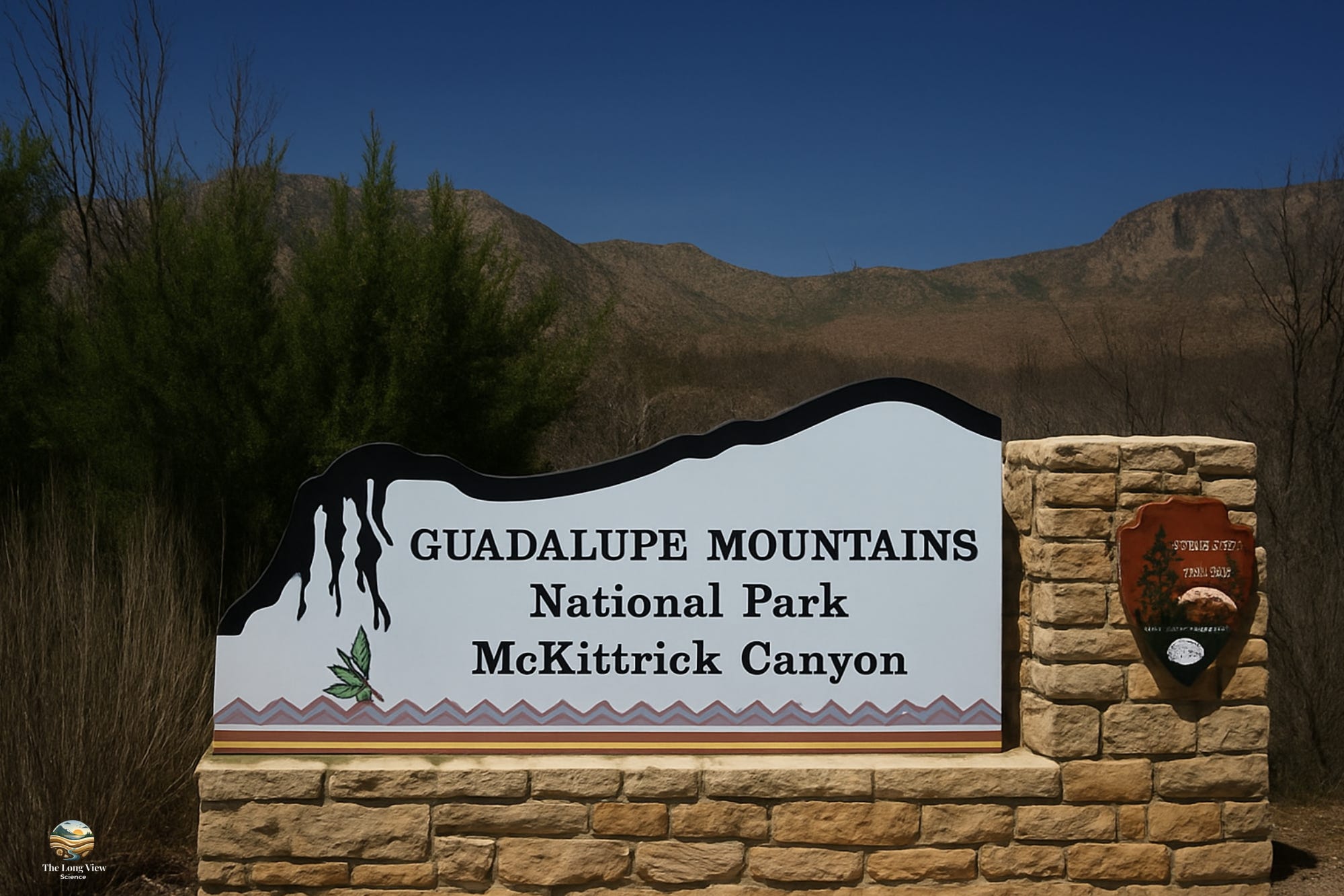
There are hikes that offer beautiful scenery and then there are hikes that genuinely reframe how you understand the world. The Permian Reef Trail in Guadalupe Mountains National Park, tucked into the far corner of West Texas near the New Mexico border, belongs firmly in the second category.
At roughly 13 km round-trip with 610 m of elevation gain, it is not the longest or most gruelling trail in the park, but certainly is the most intellectually stimulating. We’re not just walking up a mountain. We are effectively on a journey through a Permian seascape that teemed with life 265 million years ago.
An Ancient Sea in West Texas
The Guadalupe Mountains are, at their geological core, the exposed remnant of the Capitan Reef, one of the largest and best-preserved ancient reef complexes anywhere on Earth. During the Permian Period, this region sat at the edge of a warm, shallow inland sea called the Permian Basin (a name you probably recognize today for a very different reason: it is now one of the most productive oil and gas regions in North America).
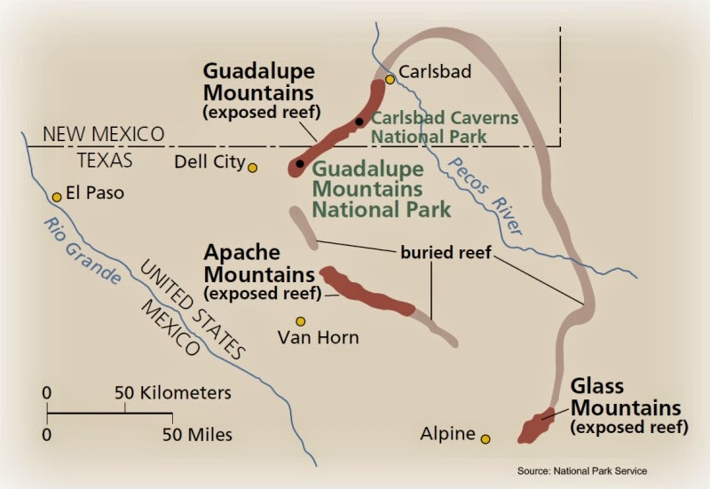
Permian Reef of West Texas and New Mexico. The red part of the reef indicates where the rocks are exposed at the surface. (Image from https://www.beg.utexas.edu/texas-through-time/el-capitan.html)
That sea teemed with life. Colonies of bryozoans (small filter-feeding invertebrates) sponges, and algae built up the reef structure over millions of years, while brachiopods, ammonoids, and crinoids populated the surrounding waters.
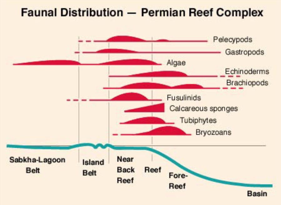
Distribution of major fossil groups across the Permian Reef Complex (image from Scholle, 2020)
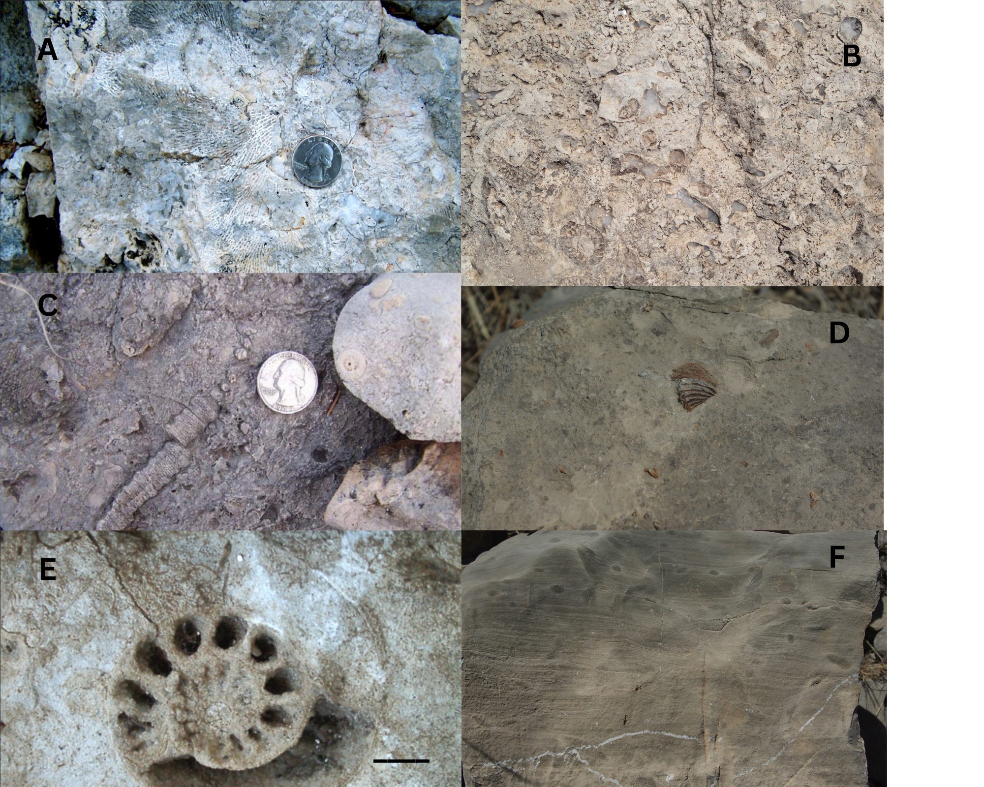
Examples of common fossils found on the Permian Reef Trail. Scale is the same for all photos except E; the scale bar in E is 1 cm.
A: Bryozoans (photo from NPS Identification Guid to the Fossils); B: Sponges; C: Crinoids (photo from NPS Identification Guid to the Fossils); D: Brachiopod; E: Ammonoid; F: Algal lamination
Then the sea dried up. Over tens of millions of years, the reef was buried under sediment, compressed, mineralized, and eventually uplifted. What erosion left behind is what you see today: a sheer, fossil-studded limestone escarpment rising dramatically from the Chihuahuan Desert.
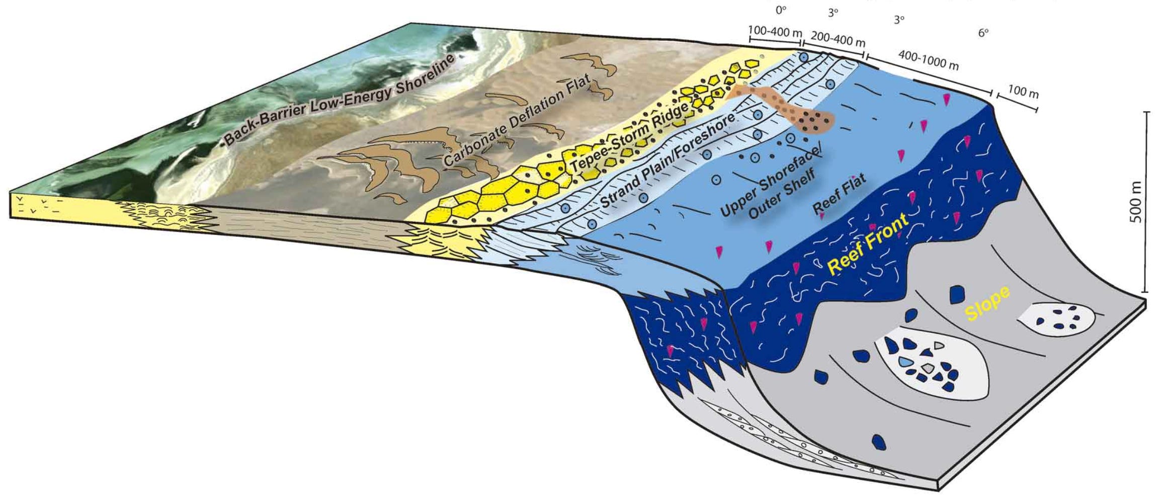
Generalized cross section of the Permian Capitan Reef Complex (Guadalupe Mountains, west Texas and New Mexico), illustrating the spatial relationships from the Basin to the backreef–lagoon sections (Image from IUGS)
The Permian Reef Trail was designed specifically to let visitors explore this geological story in sequence beginning at the toe of the reef slope, progressing upward through the slope, to the reef proper and finally, at the very top of the trail, into the backreef and shelf sections. A detailed trail guide, edited by geologists D. G. Bebout and C. Kearns, correlates numbered stops along the trail with specific sedimentological features. It reads less like a hiking pamphlet and more like a field guide for a university geology course, which tells you something about the trail’s unusual character. Each year, dozens, if not hundreds, of geology students make the pilgrimage to West Texas to hike the trail, part of a long-standing tradition that has shaped generations of Earth scientists.
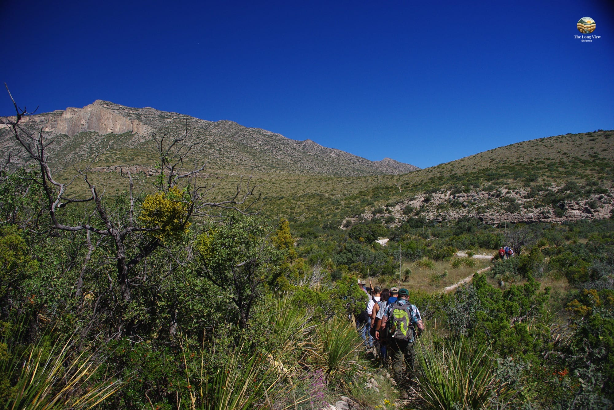
A group of geoscientists beginning the treck up the Permian Reef Trail.
The Hike
The trail begins at the the McKittrick Canyon Contact Station, but our first stop is going to be at the Pine Springs Visitor Center, which is well-equipped and staffed by rangers who genuinely enjoy talking about the geology. After taking in the dioramas we’ll pick up any interpretive guides there (see reading list at end); these are essential and transform an already remarkable hike into something closer to a time-travel experience. From there it’s a short 20 km drive to the trailhead at McKittrick Canyon.
The first stretch of trail moves through typical Chihuahuan Desert terrain: scrubby vegetation, loose rock, prickly pear and lechuguilla giving way to sotol as we slowly gain elevation. Lechuguilla, a spiky desert plant with sharply pointed leaves, is a good ecological indicator: it grows almost exclusively in the Chihuahuan Desert, making it a signature species of the region.
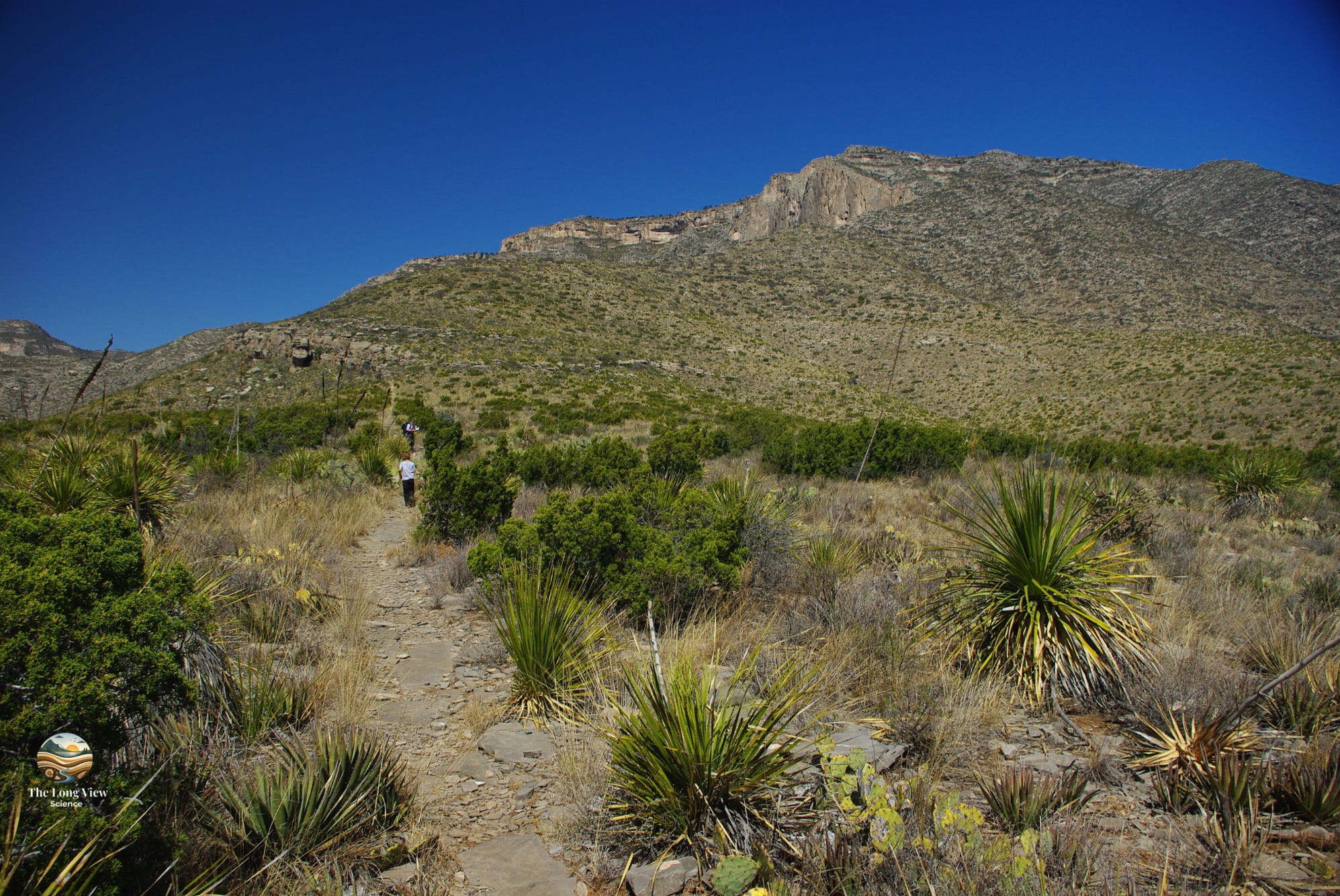
Lower part of the trail traversing the toe of the reef slope shows abundant prickly pear and lechuguilla.
As we climb, the character of the rock begins to demand more attention. The thinly bedded basinal sediments we noticed at the start of the hike grade to limestones thick with fossils just about everywhere we step. The fossils are not buried or hidden, but right there on the surface, worn smooth by centuries of wind. Sponge colonies, the remains of calcareous algae, and brachiopod shells are embedded in the walls and underfoot. These are not rare finds that require careful searching. We are literally traversing up the reef slope; the many fossils making up the rock were being shed from the reef crest many meters above us.
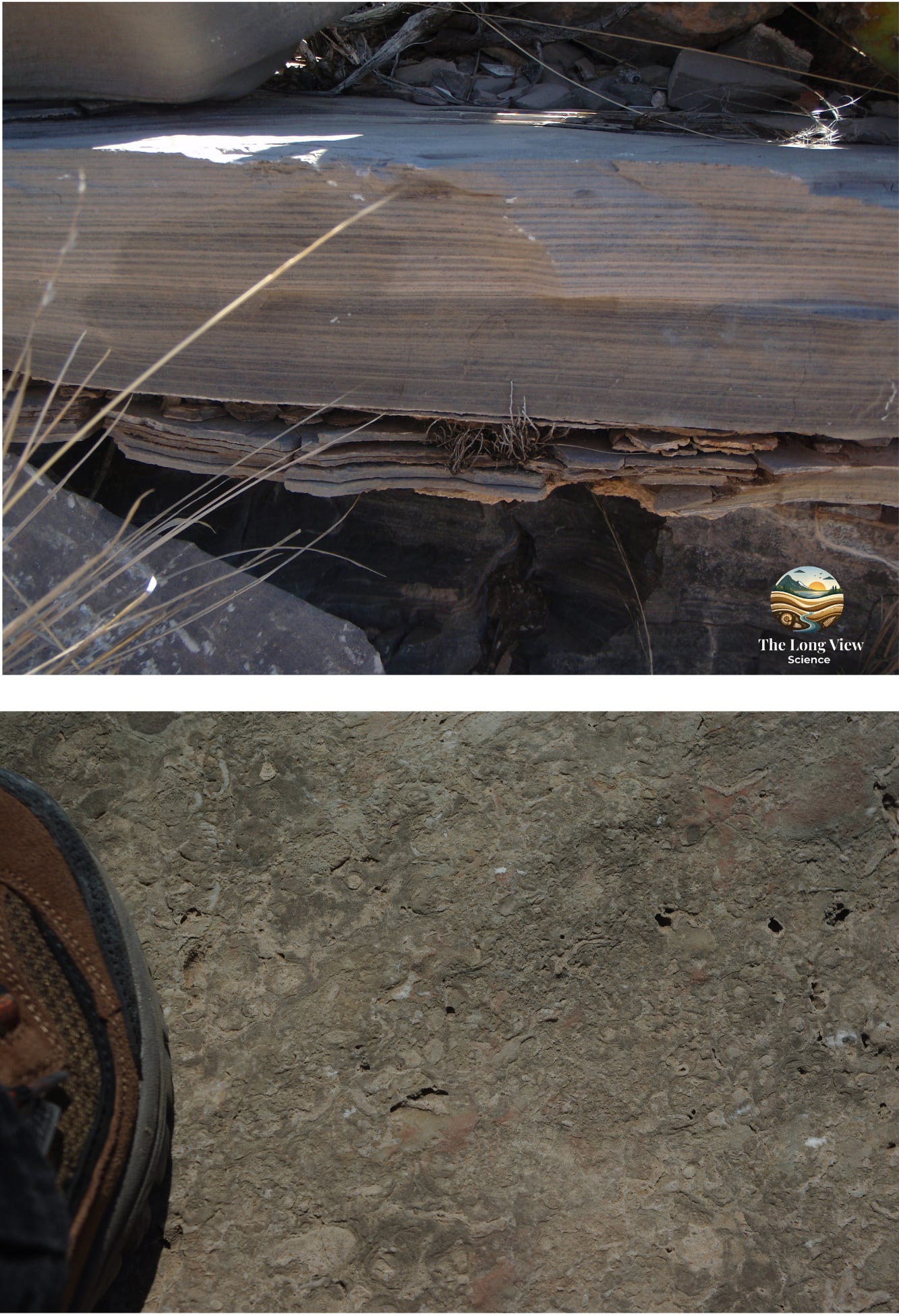
Examples of sediments you’ll see in the lower reef slope section of the trail.
Upper: Thin bedded and laminated fine grained carbonates in the lower part of the trail were probably deposited by low density turbidity flow currents.
Lower: An example of fossiliferous limestone comprising a slump deposit that probably slid about 300 m down from the reef crest.
After about a kilometre of easy walking, the trail steepens as it ascends toward the canyon wall, offering increasingly expansive views across the desert floor. To the south and east, the salt flats shimmering in the distance remind us that the basinal area offshore from the Capitan Reef was once a large evaporitic arm of the Permian sea. On a clear day, the views are spectacular, extending for dozens of km southeastward into Texas; to the west we get a glimpse of the rugged terrain of the interior of the park.
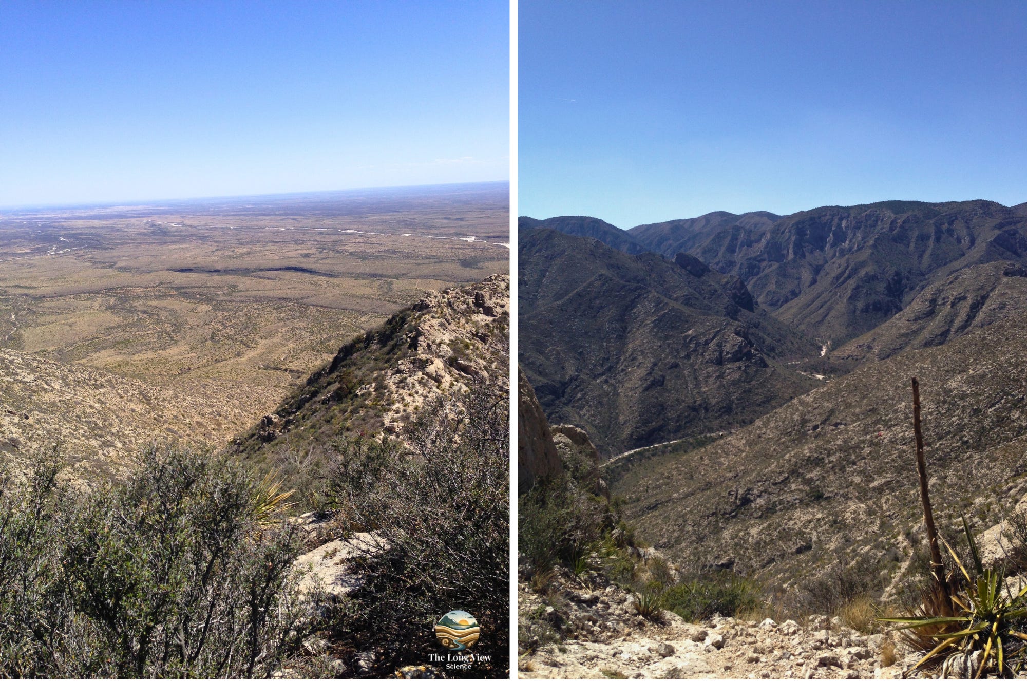
Views from near the crest of the Permian Reef Trail.
Left is looking southeastward toward Pecos, Texas (about 150 km) with the Delaware River in the mid-ground.
Right is looking westward up McKittrick Canyon into the interior of the Guadalupe Mountains.
As the ascent continues to steepen, we’ll begin to notice another change in the rocks. We’re passing from the toe of the slope, up into a series angular chaotic blocks and breccias that represent carbonate material slumped off the steep forereef.
About 3 km in and 400 m up, the massive limestone of the reef crest finally comes into view: the core of the Capitan Reef itself. The layering here is nothing like sediment that has been deposited on a flat sea floor; instead it represents the forward and upward growth of the living reef framework.
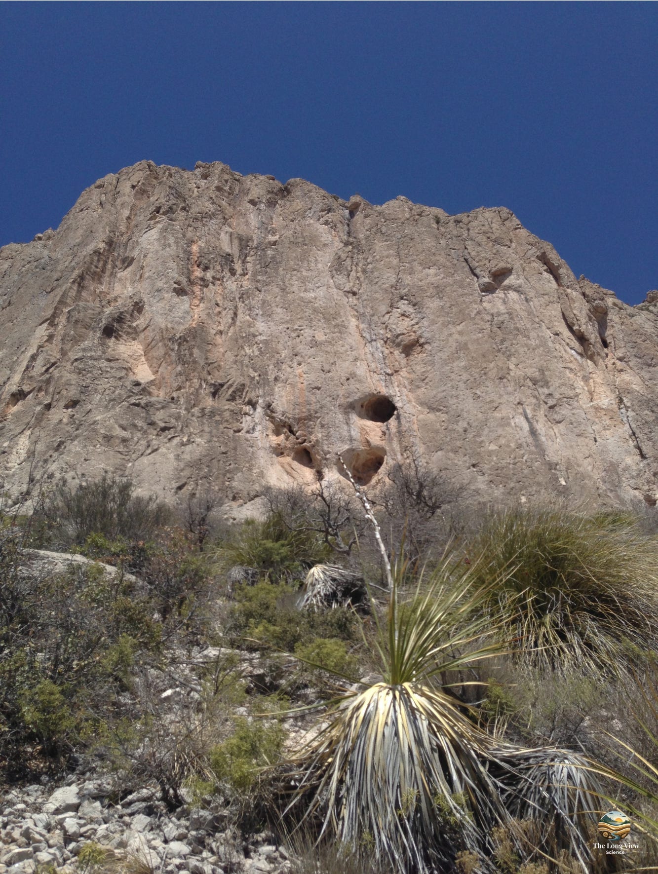
The imposing 150 m thick massive limestone of the Capitan Reef. The caves in the lower portion of the outcrop were probably formed concurrently with others in the Guadalupe Mountains such as Carlsbad Caverns.
The Bigger Picture
It is worth pausing somewhere on this trail with the desert spread out far below us and fossil sponges at eye and foot level, to absorb the full temporal scale of what we’re experiencing. The Permian Period ended about 252 million years ago in the largest mass extinction in Earth’s history: the Great Dying (Permian-Triassic Extinction Event), which resulted in the loss of 90% of total life on the planet. The reef we are climbing predates that catastrophe. The organisms whose remains we are touching lived and died tens of millions of years before the first dinosaurs appeared.
The Guadalupe Mountains became a national park in 1972, in part because of their remarkable geological significance. El Capitan, the prominent peak visible for km across the desert and one of the defining landmarks of West Texas, is essentially the massive corner buttress of the ancient reef front, now standing 2464 m above sea level.
Practical Considerations
The Permian Reef Trail is rated moderate to strenuous; this rating is honest. The upper sections involve loose rock and sustained climbing, and the elevation gain is real. Water is non-negotiable in this environment with summer temperatures routinely exceeding 38oC in the lower elevations. Most critical is that the trail offers almost no shade. Spring and fall are the ideal seasons, when temperatures are moderate and the desert flora is often at its most striking.
Wildlife sightings are common. Mule deer, elk, and the occasional black bear inhabit the park. Rattlesnakes are also common on the trail but largely indifferent to hikers who give them appropriate space. More charming are the collared peccaries, known locally as javelinas, which can sometimes be spotted near the McKittrick station in the early morning.
The park is close to Carlsbad Caverns National Park in New Mexico, about 50 km to the northeast. Carlsbad, formed largely by sulfuric acid dissolving the same Capitan Reef limestone from below, offers a fascinating underground complement to the surface geology of the Reef trail. The two parks together make for a compelling multi-day visit.
Why This Trail Matters
Most of us move through the world with a shallow sense of geological time. We understand intellectually that the Earth is old, but the understanding rarely has much emotional texture to it. The Permian Reef Trail is one of the rare places where that abstraction becomes concrete; where you can press your hand against limestone and know, not just believe, that you are touching a living ecosystem from a world unimaginably different from our own.
The reef builders are all gone; many are extinct. The sea they lived in is gone. The continent they inhabited has moved thousands of kilometres from where it began. And yet the record of their existence is here, in extraordinary detail, in a stack of limestone at the edge of a West Texas desert, waiting for anyone willing to make the climb.
The Permian Reef Trail won’t make the highlight reels of social media the way Zion’s Angels Landing or the Grand Canyon’s South Rim will. There are no sweeping arches, no rainbow-painted cliffs. What it offers instead is rare: a place where the ground beneath our boots tells a coherent, verifiable story that took place a quarter of a billion years ago. And that’s the quiet power of this place: it doesn’t just show us Earth’s history, it lets us inhabit it, if only for a few hours.
That, more than any summit, is worth the drive to West Texas.
Next in the series: Carlsbad Caverns: discover how oil, acid, and time generated a spectacular cave system in these Permian limestones.
There is a lot written about Guadalupe National Park in general and the Permian Reef Trail in particular. Be sure to grab these to take along on your hike.
Many guide books and references have been published for the Permian Reef Trail at Guadalupe Mountains National Park. Here is a sampling.

Primary Trail & Geological Guides
Bebout, D.G., and Kerans, C. (eds.), 1993. Guide to the Permian Reef Geology Trail: McKittrick Canyon, Guadalupe Mountains National Park, west Texas. Bureau of Economic Geology, University of Texas at Austin, Guidebook 26, 48 p.
The essential field guide for the trail, written by professional geologists and available through the Bureau of Economic Geology store ($11). A pdf is also available free online through the National Park History and Archive site.
King, P.B., 1948. Geology of the Southern Guadalupe Mountains, Texas. U.S. Geological Survey Professional Paper 215, 183 p.
The foundational geological survey of the Guadalupe Mountains — still a landmark reference nearly 80 years after publication.
Newell, N.D., Rigby, J.K., Fischer, A.G., Whiteman, A.J., Hickox, J.E., and Bradley, J.S., 1953. The Permian Reef Complex of the Guadalupe Mountains Region, Texas and New Mexico: A Study in Paleoecology. W.H. Freeman, San Francisco, 236 p.
A foundational paleoecological study of the Capitan Reef system.
National Park Service & USGS Official Resources
U.S. National Park Service. Guadalupe Mountains National Park — Official Park Website.
The NPS homepage for the park, with current visitor information, trail conditions, and interpretive resources.
U.S. National Park Service History. Guadalupe Mountains National Park, Texas.
A detailed summary of the history of the park with an extensive bibliography. If you are interested in learning more about the park make this your first stop for references. This web page includes links to all the major books, brochures, and reports dealing with the Guadalupe National Park.
U.S. Geological Survey. Geology of Guadalupe Mountains National Park. USGS Geology and Ecology of National Parks series.
Accessible overview of the park’s geological history, including the formation of the Capitan Reef and Delaware Basin.
U.S. Geological Survey. Ecology of Guadalupe Mountains National Park. USGS Geology and Ecology of National Parks series.
Overview of the park’s biodiversity, including mammal, bird, and reptile species counts and habitat descriptions.
U.S. National Park Service. NPS Geodiversity Atlas — Guadalupe Mountains National Park, Texas.
Details the park’s designation as a Global Boundary Stratotype Section and Point (GSSP) for the Middle Permian.
U.S. National Park Service. NPS Identification Guid to the Fossils of Guadalupe Mountain National Park. https://npshistory.com/publications/gumo/fossil-guide.pdf
This color illustrated guide describes the fossils of Guadalupe Mountains National Park and explains how they formed within the Permian Capitan Reef, helping visitors identify common fossil organisms and understand the ancient marine ecosystem that built the reef.
Capitan Reef & Permian Basin Geology
Kerans, C., Phelps, R.M., Dury, M., Playton, T., Bachtel, S., and Scott, S., 2021. Natural laboratory for studying stratigraphic architecture, facies tract distribution and syndepositional deformation in carbonate ramps and steep-rimmed platforms: Guadalupe Mountains, West Texas and New Mexico. SEPM Special Publication, pp. 129–178.
Details how the Guadalupe Mountains serve as a premier analog for understanding the complex layers, sediment patterns, and structural shifts within both sloping and steep-walled carbonate platforms.
International Union of Geological Sciences (IUGS) GeoHeritage. Permian Reef Complex of the Guadalupe Mountains. IUGS GeoHeritage Sites.
Overview of the site’s international scientific significance, with bibliography of major research.
Virtual Field Trips & Miscellaneous Online Resources
Scholle, P., Permian Reef Complex Virtual Field Trip. New Mexico Bureau of Geology and Mineral Resources. https://geoinfo.nmt.edu/tour/federal/parks/PermianReef/stops/pmstop2_1.html
An essential detailed online field trip developed for geology students, with photographs, roadlogs, and extensive bibliography.
The Permian Basin Petroleum Museum. Midland, Texas. https://www.virtually-anywhere.net/tours/petroleummuseum/index.htm
A virtual tour of the museum with over 20 360o views of each of four major galleries.
General Park & Regional Context
Texas State Historical Association. 2024. Guadalupe Mountains National Park. Handbook of Texas Online.
Authoritative overview of the park’s natural history, cultural history, and establishment as a national park in 1972.
Kues, B.S., 2006. Geological studies of the Guadalupe Mountains area — a historical review through 1928. New Mexico Geological Society Guidebook, 57th Field Conference, pp. 127–144.
A useful historical account of how geologists came to understand the reef nature of the Guadalupe Mountains, from the first surveys in the 1850s through the 1920s oil boom.
We live along the Petitcodiac River, known as Petkootkweag, on the traditional and unceded territory of the Wolastoqey (Maliseet), Mi’kmaq, and Passamaquoddy Peoples of the Wabanaki Confederacy. This river has shaped life and movement here for generations. We offer this acknowledgement with gratitude and as a commitment to listen, learn, and care for this land and water with intention.
What a brilliant piece.
This feels as close as someone can get to the brilliant geology, without taking the long (and expensive) trip from the U.K. Thank you for writing.